Manaslu Circuit Villages: Complete Village-by-village Guide
By Nepal Trekking Trail On 28 Sep 2026

Quick Contact
By Nepal Trekking Trail On 28 Sep 2026
The villages of the Manaslu Circuit lie mostly in the northern part of Gorkha district, in the Budhi Gandaki valley, which runs from the warm lowlands near Arughat right up to the Tibetan border. Much of the upper trekking route falls within Chumnubri Rural Municipality, the local government area that covers both the Nubri valley and the Tsum Valley. After crossing Larkya La, the trail leaves Gorkha and descends into Manang district, where the final villages of the trek, from Bimthang to Dharapani, belong to the Annapurna side.
What makes these villages special is how much they change over a single trek. In just a few days, you walk from Hindu farming villages to communities whose language, faith, architecture and way of life are closely tied to Tibet. The villages can be understood in four broad zones.
The lower valley villages, from Arughat and Soti Khola up to Jagat and Philim, are home to Gurung, Magar, Brahmin, Chhetri and other hill communities. Life here follows the rhythm of terraced farming, with rice, millet and maize growing on steep hillsides. Houses are built from stone and mud with slate or tin roofs, and small Hindu shrines, water-powered mills and local shops are part of everyday life. The climate is warm and subtropical, and the villages are relatively close to road access.
The Kutang villages, roughly from Deng to around Ghap and Prok, form a cultural bridge between the lower and upper valley. The people here speak their own language, and Buddhist features such as mani walls, carved prayer stones and chortens begin to dominate the trail. Villages are smaller and more scattered, with forest, bamboo and river crossings between them.
The Nubri villages, from Namrung through Lihi, Sho, Lho, Shyala and Samagaun up to Samdo, are the heart of the upper Manaslu region. The Nubri people are of Tibetan origin, follow Tibetan Buddhism and speak a Tibetan dialect. Their villages have flat-roofed stone houses built close together for warmth, kani gateways at the entrance, long mani walls, prayer wheels and monasteries such as Ribung Gompa in Lho and Pungyen Gompa above Samagaun. Families grow barley, buckwheat and potatoes in short summer seasons, herd yaks and other livestock, and have long histories of trade with Tibet. Samdo, the highest permanent village on the circuit, sits only a few days' walk from the border.
The Tsum Valley villages, on the optional side trip from Lokpa to Chule and Nile, belong to the Tsumba community, with their own dialect and customs. The valley is known for its sacred sites, including Mu Gompa, Rachen Gompa and Milarepa's cave, and for long-standing local traditions against hunting and killing animals.
Across all these zones, daily life is shaped by altitude, isolation and the seasons. In the upper villages, winters are long and harsh, and some families move to lower areas during the coldest months. Many younger people now study or work in Kathmandu or abroad, while tourism has become an important source of income. Teahouses run by local families are where most trekkers stay, which means your visit directly supports these communities.
Because the region has been a restricted area since it opened to trekkers in the early 1990s, the villages of Manaslu have changed more slowly than those on Nepal's busier trails. For trekkers, walking from village to village is a rare chance to see traditional mountain life, living Buddhist culture and the deep connection between people and the landscape of the Himalaya.
| Fact | Details |
|---|---|
| Elevation | About 570 m |
| Section | Lower Budhi Gandaki Valley |
| People | Mixed hill communities |
| Role on the Trek | Market town on the drive in |
Overview: Arughat is the busy bazaar town where the road from Kathmandu enters the Budhi Gandaki valley. The river splits the town between Gorkha and Dhading districts. It is the last proper market town before the trail, with shops, small hotels and supplies.
Interesting Points: It is the last good stop for snacks, batteries and cash, and it gives trekkers their first view of the Budhi Gandaki, the river they will follow for most of the trek.
| Fact | Details |
|---|---|
| Elevation | About 710 m |
| Section | Lower Budhi Gandaki Valley |
| People | Gurung, Magar and others |
| Role on the Trek | Traditional trailhead and first overnight stop |
Overview: Soti Khola is a small riverside village where a stream joins the Budhi Gandaki. For many years it was where the road ended and walking began. Jeeps now often continue further, but some itineraries still start here.
Interesting Points: The warm subtropical surroundings of sal forest, banana plants and terraced fields mark the very beginning of a climate journey that ends in snow and ice at Larkya La.
| Fact | Details |
|---|---|
| Elevation | About 880 m |
| Section | Lower Budhi Gandaki Valley |
| People | Gurung |
| Role on the Trek | Trail village |
Overview: Lapubesi is a Gurung village perched on the hillside above the Budhi Gandaki gorge. The trail climbs up and down through rice terraces and along cliff edges.
Interesting Points: The views down into the narrow gorge are dramatic, and the stone Gurung houses show classic hill architecture.
| Fact | Details |
|---|---|
| Elevation | About 930 m |
| Section | Lower Budhi Gandaki Valley |
| People | Gurung and mixed |
| Role on the Trek | Common first night on the trail |
Overview: Machha Khola means "fish river." The village sits beside a tributary of the Budhi Gandaki and is the usual first overnight stop on most modern itineraries, with a good number of teahouses and small shops.
Interesting Points: The name comes from the fish once caught in the river here. In the dry season, many trekkers arrive directly by jeep, making this their first teahouse night.
| Fact | Details |
|---|---|
| Elevation | About 970 m |
| Section | Lower Budhi Gandaki Valley |
| People | Gurung |
| Role on the Trek | Trail village |
Overview: Khorlabesi is a peaceful farming village surrounded by terraces of rice, millet and maize. The trail passes right through its lanes.
Interesting Points: It is a good place to see traditional farming life in the lower valley, and its small teahouses make a convenient tea or lunch stop.
| Fact | Details |
|---|---|
| Elevation | About 990 m |
| Section | Lower Budhi Gandaki Valley |
| People | Mixed |
| Role on the Trek | Lunch or rest stop |
Overview: Tatopani means "hot water," and the village is named for its natural hot springs. Warm spring water is piped into simple taps where locals and trekkers wash.
Interesting Points: It is one of the few hot springs on the entire circuit, and a quick wash here is a real treat after a sweaty morning's walk.
| Fact | Details |
|---|---|
| Elevation | About 1,070 m |
| Section | Lower Budhi Gandaki Valley |
| People | Mixed |
| Role on the Trek | Trail village |
Overview: Dobhan means "confluence," and the village sits where a side stream meets the Budhi Gandaki. The valley narrows here, and the trail crosses suspension bridges and rocky sections.
Interesting Points: The river becomes much wilder around Dobhan, with powerful rapids below the trail.
| Fact | Details |
|---|---|
| Elevation | About 1,170 m |
| Section | Lower Budhi Gandaki Valley |
| People | Mixed |
| Role on the Trek | Trail stop |
Overview: Yaru Khola is a small settlement on the way to Jagat. The trail passes through forest, open river flats and cliffside paths.
Interesting Points: This section has some of the most impressive waterfalls in the lower valley, and it makes a quiet break before the climb to Jagat.
| Fact | Details |
|---|---|
| Elevation | About 1,340 m |
| Section | Lower Budhi Gandaki Valley |
| People | Gurung and mixed |
| Role on the Trek | Restricted area and conservation area entry checkpoint |
Overview: Jagat is the gateway to the Manaslu Restricted Area and Manaslu Conservation Area. Permits are checked here and the local municipality fee is collected. The village has attractive flagstone paths and neat stone houses.
Interesting Points: This is where the trek officially begins, since your guide registers the group at the checkpoint. Its flagstone-paved streets are among the prettiest in the lower valley.
| Fact | Details |
|---|---|
| Elevation | About 1,440 m |
| Section | Lower Budhi Gandaki Valley |
| People | Mixed |
| Role on the Trek | Trail village |
Overview: Salleri is a small village just above Jagat. The trail climbs gently through terraces and open hillsides with good valley views.
Interesting Points: It is often the first place where Shringi Himal appears in the distance.
| Fact | Details |
|---|---|
| Elevation | About 1,420 m |
| Section | Lower Budhi Gandaki Valley |
| People | Mixed |
| Role on the Trek | Trail village |
Overview: Sirdibas is where the first signs of Tibetan Buddhist culture appear. Prayer flags, mani stones and small chortens begin to line the trail.
Interesting Points: The first mani walls on the route signal the cultural shift ahead. For trekkers adding the Tsum Valley, permit days are counted from around here.
| Fact | Details |
|---|---|
| Elevation | About 1,570 m |
| Section | Lower Budhi Gandaki Valley |
| People | Gurung |
| Role on the Trek | Overnight stop |
Overview: Philim is a large, prosperous Gurung village surrounded by millet and maize fields. It has a school, several teahouses and a small monastery, Naksa Chhyoling Gompa.
Interesting Points: It is one of the larger villages in the lower valley and a pleasant overnight stop. Beyond Philim, the trail enters a deeper, more forested gorge.
| Fact | Details |
|---|---|
| Elevation | About 1,600 m |
| Section | Lower Budhi Gandaki Valley |
| People | Mixed |
| Role on the Trek | Trail stop and Tsum Valley junction area |
Overview: Ekle Bhatti means "single inn," a reference to the lone teahouse that once stood here. It is now a small cluster of lodges near the junction where the Tsum Valley trail branches toward Lokpa.
Interesting Points: The gorge is steep and narrow here, with the river roaring below. This is where Tsum Valley trekkers split from the main route.
| Fact | Details |
|---|---|
| Elevation | About 1,860 m |
| Section | Middle Valley (entering Nubri) |
| People | Kutang and Nubri |
| Role on the Trek | Overnight stop |
Overview: Deng marks the beginning of the upper valley's Tibetan-influenced culture. House styles change, and the people speak a Tibetan-related language. Bamboo forest surrounds the village.
Interesting Points: Many trekkers notice the clear cultural shift from Hindu to Buddhist here. The surrounding forest is home to langur monkeys and many bird species.
| Fact | Details |
|---|---|
| Elevation | About 1,910 m |
| Section | Middle Valley (entering Nubri) |
| People | Nubri |
| Role on the Trek | Trail village |
Overview: Rana is a small village reached by crossing the Budhi Gandaki on a suspension bridge after Deng. The trail climbs through fields and forest toward Bihi Phedi.
Interesting Points: It is quiet and rural, with few trekkers staying overnight, and the valley views begin to open up here.
| Fact | Details |
|---|---|
| Elevation | About 1,990 m |
| Section | Middle Valley (entering Nubri) |
| People | Nubri |
| Role on the Trek | Trail village and lunch stop |
Overview: Bihi Phedi sits at the foot of the hillside village of Bihi. The trail passes carved mani stones and prayer walls.
Interesting Points: Look out for the beautifully carved mani stones along the trail.
| Fact | Details |
|---|---|
| Elevation | About 2,160 m |
| Section | Middle Valley (entering Nubri) |
| People | Nubri |
| Role on the Trek | Trail village |
Overview: Ghap is known for its long mani walls and carved prayer stones, some depicting Buddhist deities. The trail crosses the river several times in this section.
Interesting Points: The carved stones here are some of the finest on the route, and the forest beyond is rich in rhododendron, pine and oak, especially colorful in spring.
| Fact | Details |
|---|---|
| Elevation | About 2,400 m |
| Section | Middle Valley (entering Nubri) |
| People | Nubri |
| Role on the Trek | Optional detour across the river |
Overview: Prok is a traditional village on a plateau across the river from the main trail, with beautiful views of Shringi Himal and a slow, rural atmosphere.
Interesting Points: A side trip leads to Kal Tal lake and Kal Chhokang Gompa. Few trekkers visit, so village life here is uncrowded.
| Fact | Details |
|---|---|
| Elevation | About 2,630 m |
| Section | Middle Valley (entering Nubri) |
| People | Nubri |
| Role on the Trek | Overnight stop and permit checkpoint |
Overview: Namrung is a well-developed village with good teahouses, and permits are checked again here. Namla Gompa is in the village.
Interesting Points: The first good views of Manaslu, Siringi and Ganesh Himal appear from Namrung, and it has some of the more comfortable lodges on the circuit.
| Fact | Details |
|---|---|
| Elevation | About 2,920 m |
| Section | Upper Nubri Valley |
| People | Nubri |
| Role on the Trek | Trail village |
Overview: Lihi is a traditional Nubri village surrounded by barley fields. A kani (gateway chorten) marks its entrance, and the houses are built in classic Tibetan style from stone and timber.
Interesting Points: Hinang Gompa is about 2 hours' hike away as a side trip, and the views of Manaslu North widen from here.
| Fact | Details |
|---|---|
| Elevation | About 2,960 m |
| Section | Upper Nubri Valley |
| People | Nubri |
| Role on the Trek | Trail village |
Overview: Sho is a small village with chortens, prayer wheels and mani walls. The trail climbs steadily toward Lho with increasingly dramatic mountain views.
Interesting Points: Naike Peak and Manaslu North are visible on clear days. Spin the prayer wheels as you pass, always clockwise.
| Fact | Details |
|---|---|
| Elevation | About 3,180 m |
| Section | Upper Nubri Valley |
| People | Nubri |
| Role on the Trek | Overnight stop |
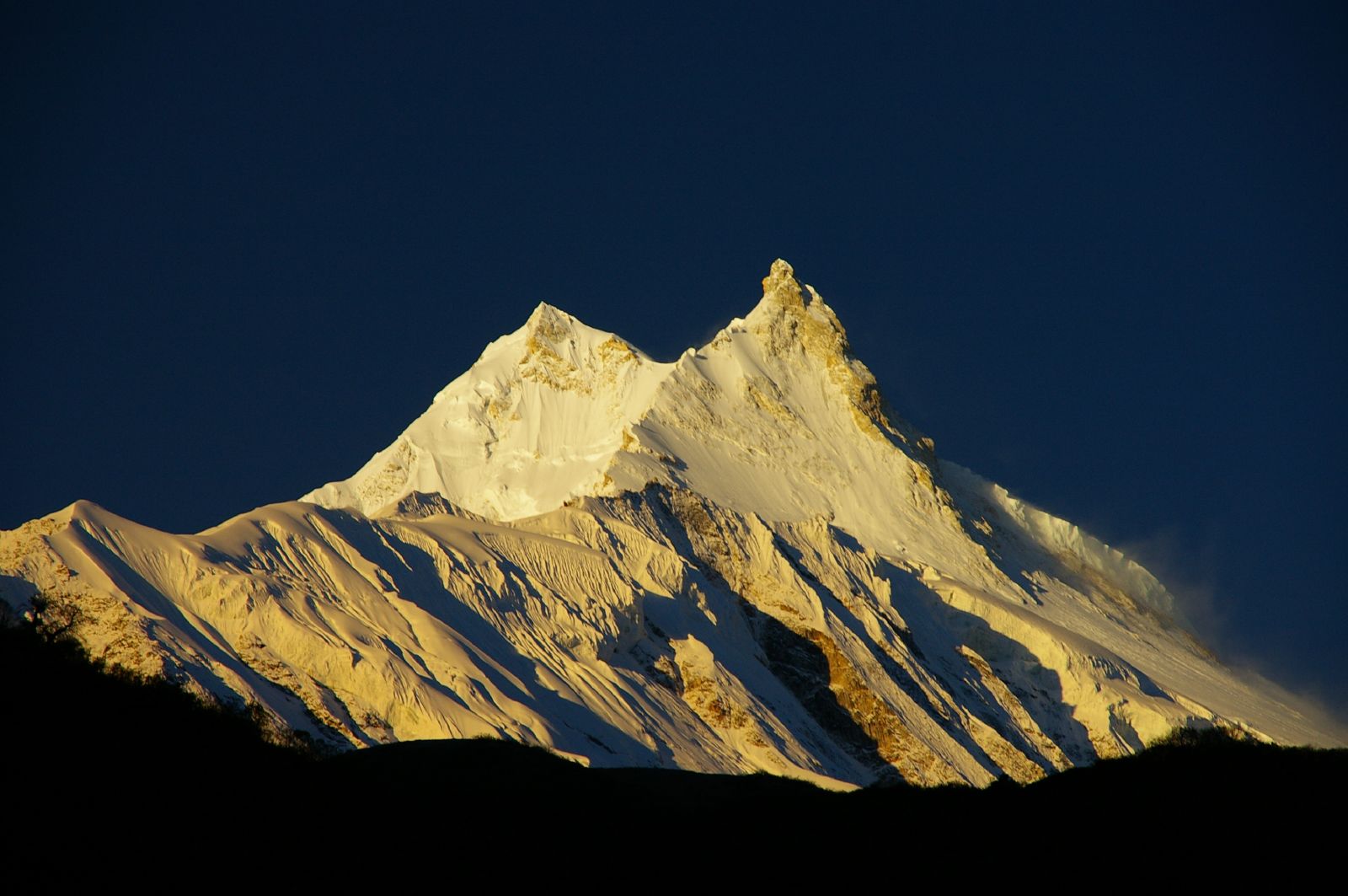
Overview: Lho is one of the most photogenic villages on the circuit. Ribung Gompa sits on a hill above the village, with Manaslu's twin summits rising behind it.
Interesting Points: Sunrise from Ribung Gompa, with chortens in the foreground and Manaslu behind, is one of the trek's iconic views. The monastery is one of the oldest on the route and has resident monks.
| Fact | Details |
|---|---|
| Elevation | About 3,500 m |
| Section | Upper Nubri Valley |
| People | Nubri |
| Role on the Trek | Trail village |
Overview: Shyala sits in a wide, open valley surrounded by an amphitheater of peaks, including Himal Chuli, Peak 29 and Manaslu. Pungyen Gompa lies above the village.
Interesting Points: The panorama here is one of the widest on the entire route, and yak pastures and potato fields surround the village.
| Fact | Details |
|---|---|
| Elevation | About 3,530 m |
| Section | Upper Nubri Valley |
| People | Nubri |
| Role on the Trek | Main acclimatization stop |
Overview: Samagaun (Sama) is the largest village in the upper valley and the cultural center of Nubri. It has many teahouses, shops, a health post and Sama Gompa, and it serves as the base for Manaslu expeditions.
Interesting Points: Popular side trips include Pungyen Gompa, Birendra Tal and Manaslu Base Camp (about 4,800 m). Pungyen Gompa's Tiji (Tenchi) festival is usually held in May, and you may see women spinning wool and weaving outside their homes.
| Fact | Details |
|---|---|
| Elevation | About 3,875 m |
| Section | Upper Nubri Valley |
| People | Tibetan-origin families |
| Role on the Trek | Second acclimatization stop |
Overview: Samdo is a high, windswept village near the Tibetan border. Many families trace their roots to villages across the border, and it was historically an important stop on trade routes.
Interesting Points: Side hikes toward the border or up the ridge above the village offer huge views, and yak herds are a constant sight.
| Fact | Details |
|---|---|
| Elevation | About 4,460 m |
| Section | Upper Nubri Valley |
| People | None (lodges only) |
| Role on the Trek | Last stop before the pass |
Overview: Dharamsala is not a real village but a small group of basic lodges at the foot of Larkya La. Nights are very cold and facilities are simple.
Interesting Points: Pass day begins here in the dark, around 3 or 4 a.m. Beds can be limited in peak season, so advance booking through your agency matters.
| Fact | Details |
|---|---|
| Elevation | 5,106 m |
| Section | High point between Nubri and Manang |
| Role on the Trek | Highest point of the trek |
Overview: Larkya La is a prayer-flag-covered pass surrounded by glaciers, and crossing it is the toughest and most rewarding day of the trek.
Interesting Points: The views take in Himlung Himal, Cheo Himal, Kang Guru and Annapurna II, followed by a long, steep descent to Bimthang.
| Fact | Details |
|---|---|
| Elevation | About 3,720 m |
| Section | Annapurna side (Manang district) |
| People | Seasonal lodges |
| Role on the Trek | Overnight stop after the pass |
Overview: Bimthang sits in a wide, flat meadow surrounded by mountains and glaciers. It was once a trading post used by Tibetan traders and now has a few simple lodges.
Interesting Points: Views of Himlung Himal, Cheo Himal and Manaslu's west face are superb at sunrise and sunset. A short walk up the moraine reveals the Salpudanda glacier.
| Fact | Details |
|---|---|
| Elevation | About 2,700 m |
| Section | Annapurna side (Manang district) |
| People | Mixed |
| Role on the Trek | Trail village |
Overview: Karche is a small settlement in the forest below Bimthang, where the trail descends along the Dudh Khola.
Interesting Points: The rhododendron, pine and birch forest is beautiful in spring, and the warmer, greener air feels very welcome after the pass.
| Fact | Details |
|---|---|
| Elevation | About 2,515 m |
| Section | Annapurna side (Manang district) |
| People | Gurung |
| Role on the Trek | Trail village |
Overview: Gho is a quiet farming village with barley and potato fields on the way down to Tilije.
Interesting Points: It offers a glimpse of farming culture on the Manang side, and its few lodges make a quiet alternative to Tilije.
| Fact | Details |
|---|---|
| Elevation | About 2,300 m |
| Section | Annapurna side (Manang district) |
| People | Gurung |
| Role on the Trek | Overnight stop |
Overview: Tilije is a large Gurung village with stone houses, narrow lanes and many teahouses. It is a popular last overnight stop on the trek.
Interesting Points: The village is known for local barley and apple products, and many trekkers celebrate their successful pass crossing here.
| Fact | Details |
|---|---|
| Elevation | About 1,965 m |
| Section | Annapurna side (Manang district) |
| People | Gurung |
| Role on the Trek | Trail village and checkpoint |
Overview: Thonje sits where the Dudh Khola meets the Marsyangdi River. A suspension bridge crosses the Marsyangdi, permits are checked here, and the village has a small gompa.
Interesting Points: This is where the Manaslu trail joins the Annapurna Circuit area, and the traditional Gurung architecture is worth a short stop.
| Fact | Details |
|---|---|
| Elevation | About 1,860 m |
| Section | Annapurna side (Manang district) |
| People | Mixed |
| Role on the Trek | End of the trek |
Overview: Dharapani is a busy village on the Annapurna Circuit road with an ACAP checkpoint. Jeeps leave from here for Besisahar, and from there to Kathmandu or Pokhara.
Interesting Points: It is the natural place to celebrate the end of the trek with your guide and porters, and some trekkers continue on the Annapurna Circuit toward Manang and Thorong La.
| Fact | Details |
|---|---|
| Elevation | About 2,240 m |
| Section | Tsum Valley (optional) |
| People | Tsumba |
| Role on the Trek | First village in the Tsum Valley |
Overview: Lokpa is reached after the Tsum trail branches off near Ekle Bhatti and has a few simple lodges.
Interesting Points: It is the gateway to the "hidden valley," where landscape and culture change quickly.
| Fact | Details |
|---|---|
| Elevation | About 2,386 m |
| Section | Tsum Valley (optional) |
| People | Tsumba |
| Role on the Trek | Overnight stop in lower Tsum |
Overview: Chumling is a traditional village with stone houses and terraced fields.
Interesting Points: It has old gompas and fine views of Shringi Himal.
| Fact | Details |
|---|---|
| Elevation | About 3,031 m |
| Section | Tsum Valley (optional) |
| People | Tsumba |
| Role on the Trek | Main village of upper Tsum |
Overview: Chhekampar is the largest village in upper Tsum and the valley's cultural center.
Interesting Points: Rachen Gompa, a large nunnery, is a few hours' walk away.
| Fact | Details |
|---|---|
| Elevation | About 3,361 m |
| Section | Tsum Valley (optional) |
| People | Tsumba |
| Role on the Trek | High village in upper Tsum |
Overview: Nile is a high Tsumba village with Tibetan-style houses and prayer flags.
Interesting Points: The quiet, little-known Gonhgye Gompa is nearby.
| Fact | Details |
|---|---|
| Elevation | About 3,347 m |
| Section | Tsum Valley (optional) |
| People | Tsumba |
| Role on the Trek | Base for Mu Gompa |
Overview: Chule lies across the river from Nile, on the route to Mu Gompa.
Interesting Points: It is the base for visiting Mu Gompa, one of the oldest and most remote monasteries in the region, close to the Tibetan border.
Discover more articles that match your interests! Explore these similar blogs packed with insights, tips, and stories to keep you inspired.
Manaslu Circuit Trekking: The Complete Guide to Nepal\\'s Last Great Wilderness Trek...